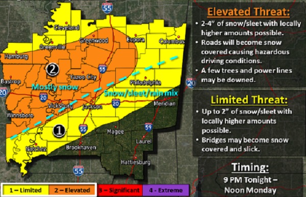
A winter storm is expected to impact our region. According to the National Weather service in Jackson, “a winter storm will impact the region from this evening through Monday morning. Mostly snow is expected north of a Vicksburg to Jackson to Philadelphia line, with a mix of snow, sleet, and rain expected south to a Brookhaven to Meridian line. South of this, impacts are not anticipated. In the elevated area, accumulations of 2-4″ are expected with higher amounts possible. Surrounding this, amounts of up to 2″ are possible in the limited area. Travel will likely be impacted across much of the area during the Monday morning commute.”
Our immediate area –
Elevated Threat – Northern parts of Leake County and Attala County are currently under an elevated threat with possible 2-4 inches of snow or sleet or more in some areas. Roads will become snow covered causing hazardous driving conditions. A few trees and power lines may be downed.
Limited Threat – Neshoba- Up to 2 inches of snow or sleet with locally higher amounts possible. Bridges may become snow covered and slick.
******* 12:15 AM Monday Carthage – Currently snowing with sleet mix and 32 degrees
We will keep you updated as additional details become available.