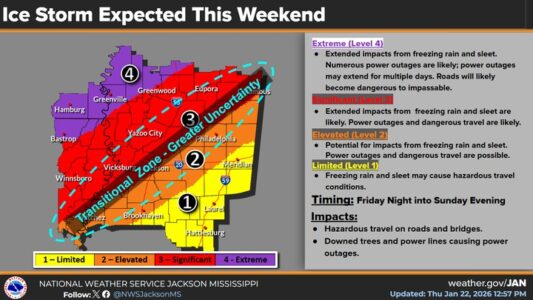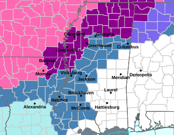
(Winter Storm Watch shown in blue-gray on map above. Ice Storm Warning shown in violet and a Winter Storm Warning is highlighted in pink.)
The National Weather Service still believes this weekend’s winter storm could have a significant impact on the northwestern half of Mississippi. Forecaster Eric Carpenter says, in some areas, we’re looking at what could be a rare combination of cold temperatures and moisture…
“A pretty unusual mix of those parameters. It doesn’t come around very often…”
And while there’s snow in the forecast for parts of this area, it’s the ice that the Weather Service is most worried about…
“We’re looking at the potential for significant amounts of freezing rain and sleet across our area and those could have some pretty major impacts…”
This part of central Mississippi could wind up with a good bit of ice and some snow, but some uncertainty has been introduced into the forecast. Carpenter says some of their computer models don’t agree on where freezing temperatures will be in place as the heaviest of the rain begins to fall. The line of uncertainty runs right through this area…
“It seems to be along the Natchez Trace…”
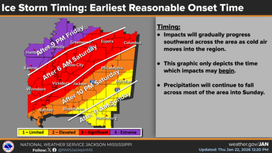
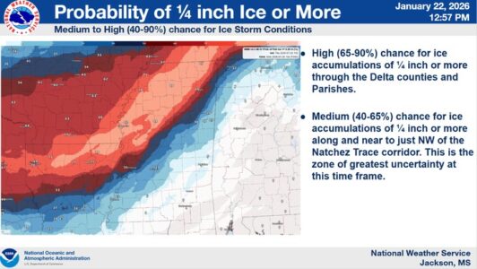
The latest thinking is that the rain may not start changing over to a wintry mix until early Saturday along and north of a Yazoo City-Columbus line, mainly in the form of freezing rain. And the Weather Service says areas southeast of the Trace may not see much in the way of winter precipitation until late Saturday or Sunday. Ice accumulations of at least a quarter-inch are possible along and northwest of the Parkway.
Much of this area will be under a winter storm watch beginning late Friday night. An ice storm warning takes effect Friday evening for most of north Mississippi and the Delta. A winter storm warning has been posted for extreme northwest Mississippi beginning Friday evening.
Some snow showers will be possible Sunday in Kosciusko and Durant but NWS now says little or no accumulations of snow are expected.
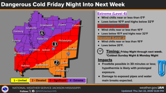
The other concern late this weekend into early next week will be the brutally cold temperatures and wind chills. Lows Sunday night are forecast to be in the lower teens in Philadelphia and around 10 degrees in Kosciusko, Carthage and Durant with chill factors near zero except in Durant where the wind could make it feel as cold as minus-5. Monday night is expected to be even worse with lows in Kosciusko and Durant in the single digits and around 10 degrees in Philadelphia and Carthage. Chill factors could again range from minus-5 in Durant to zero elsewhere in the local area.